The inventory and registration of hydrogeological boreholes for the first half of 2022 have been completed as part of the project “Systematic Inventory of Hydrogeological Boreholes of All Uses Across the Country – SAMY II,” implemented by the Hellenic Authority for Geological & Mineral Research (H.S.G.M.E.) and funded by the Operational Programme “Transport Infrastructure, Environment and Sustainable Development” under NSRF 2014–2020 (2023).
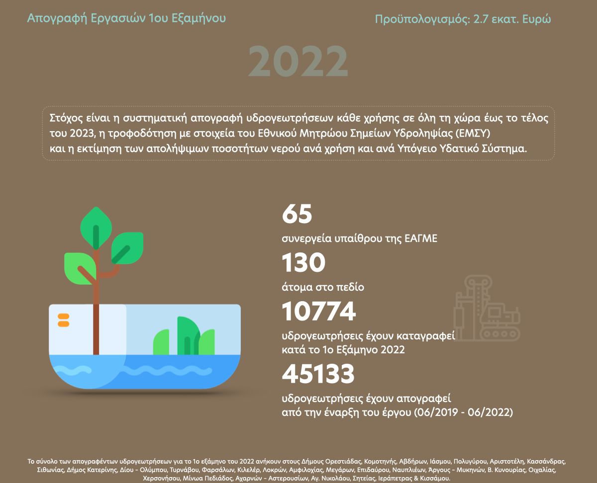
During the fieldwork conducted in January, February, March, April, May, and June 2022, a total of 65 field teams comprising 130 members participated. These field teams originated from EAGME’s Regional Units of Eastern Macedonia–Thrace, Central Macedonia, Western Macedonia, Epirus, Peloponnese, Crete, as well as from the Central Service.
The total number of inventoried hydrogeological boreholes for the first half of 2022 amounts to 10,774, located in the municipalities of Orestiada, Komotini, Avdira, Iasmos, Polygyros, Aristotelis, Kassandras, Sithonia, Katerini, Dio–Olympos, Tyrnavos, Farsala, Kileler, Lokroi, Amfilochia, Megara, Epidaurus, Nafplio, Argos–Mycenae, North Kynouria, Oichalia, Chersonissos, Minoa Pediada, Acharnae–Asterousia, Agios Nikolaos, Siteia, Ierapetra, and Kissamos.
In total, from the start of the project in June 2019 until June 2022, 45,133 hydrogeological boreholes of all uses have been recorded.
The “SAMY II” project focuses on: (a) the systematic and comprehensive recording of hydrogeological boreholes of all uses through the completion of inventory forms including technical, informational, measurement, and usage data; (b) the creation of a digital database; and (c) the estimation of extractable water quantities per Groundwater Body (GWB), as delineated in the national River Basin Management Plans.
During field inventory work, data are collected on the operational status of each borehole, primary and secondary use, technical characteristics, depth, pumping capacity, type and extent of irrigated area, and pumping schedules (days and hours). Where possible, on-site measurements of electrical conductivity (E.C., μS/cm) and groundwater level depth (m) are also taken.
Based on the inventory data, Technical Reports are prepared for each delineated Groundwater Body (GWB) included in the River Basin Management Plans. These reports include: (a) a description of geomorphological, geological, hydrogeological conditions, and land use of the GWB; (b) statistical analysis and data processing for drawing conclusions from all major parameters derived from the inventory forms; (c) mapping of all parameters on thematic maps; and (d) assessment of water balance components with classification of each GWB as either Surplus or Deficit.
The project serves as a key tool for the effective management of extractable water quantities and the protection of groundwater aquifers from overexploitation. It aims at the systematic counting of all hydrogeological boreholes within the country’s Groundwater Bodies and the recording of extractable water quantities by use (domestic, irrigation, industrial, etc.) and by GWB. Moreover, it supports the effective implementation of the EU Water Framework Directive 2000/60/EC, Directives 118/2006/EC and 676/91/EEC, and the formulation, application, and monitoring of policies related to the sustainable management of water resources.