Results of the preliminary recording of the secondary effects of the earthquake (Rockfalls – Fractures – Soil Liquefaction).
Immediately after the destructive 6.3R earthquake that struck on Wednesday, March 3, 2021, at 12:16 p.m. in the Elassona–Tyrnavos area, the Rapid Response Team for catastrophic events caused by geological factors was activated, as part of the institutional role of the Hellenic Survey of Geology and Mineral Exploration (H.S.G.M.E.).

Doméniko area: Detachment of an unstable rock block from schist-gneiss formation.
In cooperation with the competent department of the General Secretariat for Civil Protection (GSCP), the Region of Thessaly, and the Municipality of Elassona, a team of scientists from the Authority — consisting of Dr. Garyfalia Konstantopoulou, Geologist and Head of the Department of Engineering Geology (TEGE) of the Directorate of General and Applied Geology (DIGEG), and Dr. Dimitrios Galanakis, Geologist and Head of the Department of Technological Hazards (TEK) of the Directorate of Natural and Technological Risk Management (DFYTEK) — visited the area of Thessaly the following day after the event.
The team’s field inspections, carried out in cooperation with the aforementioned agencies, aimed at examining the earthquake’s secondary phenomena (landslides, rockfalls, etc.), assessing associated hazards and impacts on settlements and infrastructure, and proposing immediate protective and restoration measures, as well as conducting macroseismic observations.

Melouna area: National road Larissa–Elassona – rockfalls of fragmented and highly faulted marble blocks.
Following an inspection suggested by the Technical Service of the Municipality of Elassona, the H.S.G.M.E. team examined several high-risk areas prone to rockfalls — mainly along a section of the new Tyrnavos–Elassona highway and in the village of Doméniko — and proposed appropriate mitigation measures for each site.
Details:
- At Melouna, along the new national road from Larissa to Elassona, rockfalls of fragmented and heavily faulted marble occurred from slopes 5–30 meters high due to the earthquake. The fallen rocks did not obstruct traffic, as the protective measures functioned effectively, and the national road remained open.

Widespread soil liquefaction phenomena caused by the earthquake.
- In the village of Doméniko, near the Byzantine Church of Agioi Anargyroi, a five-cubic-meter rock detached from the gneiss-schist formation and now rests precariously, posing a risk of rolling downhill. It was recommended that the boulder be mechanically fragmented and safely removed, given the site’s easy accessibility.
- Provincial Road from the Titarissios Bridge toward Vlachogianni: Tensional cracks were observed on the road surface from the bridge extending about 2 km toward the village. Passage over the bridge — which shows no visible damage — has been temporarily prohibited for safety reasons. Similarly, the bridge over the Titarissios River toward Damasi has also been closed. In both cases, the cracks occurred in the embankment materials.

Vlachogianni Bridge connecting Elassona–Mesochori–Tyrnavos: failures in the embankment materials.
- Ground fractures and soil liquefaction phenomena were observed across the wider Vlachogianni–Praitório–Varkos area. Seismic ruptures trending NW–SE were identified within farmland and along local roads. Approximately 500 meters north of Varkos village, an expansion of ground fissures parallel to the main seismic fault was recorded, accompanied by soil liquefaction over a wide zone.

Ground fractures parallel to the seismic fault.
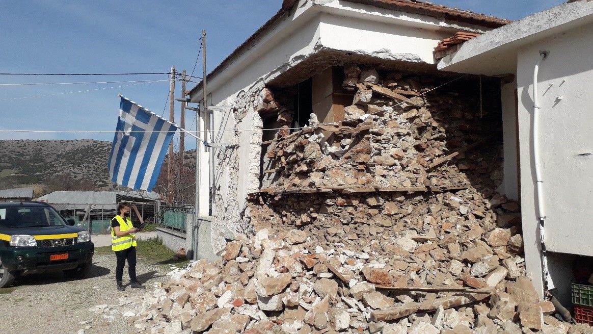
The main impact of the strong earthquake was the extensive damage to residential structures, including cracks and partial or total collapse of more than 1,000 houses across many settlements in the broader region, particularly in the villages of Damasi, Damasouli, Mesochori, Vlachogianni, Praitório, Amouri, and others.
*Header photo: Damasouli settlement – partial collapse of a house due to the earthquake.